

Ben Lui [Beinn Laoigh]
Good walks are even better shared.
Overview
Ben Lui (Beinn Laoigh) is a 1,131.4 m Munro in the southern Highlands, southwest of Tyndrum. Its twin summit cairns overlook Coire Gaothach; the southeast cairn is the true high point. The two main approaches are the long Glen Cononish return from Dalrigh and the shorter Glen Lochy outing, often combined with Beinn a' Chleibh. The western route has an unbridged river crossing, and both approaches require mountain navigation.
Ben Lui [Beinn Laoigh]
Overview
Ben Lui (Beinn Laoigh) is a 1,131.4 m Munro in the southern Highlands, southwest of Tyndrum. Its twin summit cairns overlook Coire Gaothach; the southeast cairn is the true high point. The two main approaches are the long Glen Cononish return from Dalrigh and the shorter Glen Lochy outing, often combined with Beinn a' Chleibh. The western route has an unbridged river crossing, and both approaches require mountain navigation.
Summit and landscape
The main summit is the southeast cairn at NN 26639 26288, 1,131.4 m above sea level. Ben Lui NW Top, about 150 m northwest, is lower at 1,127 m. A short dip separates the two. The summit edge overlooks the steep Coire Gaothach.
In clear weather the summit looks across the southern Highlands, including Ben Oss, Beinn Dubhchraig and the mountains around Loch Lomond. Wider views extend towards the Crianlarich hills, Rannoch Moor and Glencoe. The Glen Cononish approach reveals the twin summits and the bowl of Coire Gaothach.
Coire Gaothach lies northeast of the twin summit cairns. Glen Cononish approaches from the east, while Fionn Choire lies between Ben Lui and Beinn a' Chleibh on the western side. The Ben Lui Nature Reserve forms part of the wider Ben Lui SSSI, noted for its upland plants and Dalradian geology.
Walking routes
Ben Lui from Dalrigh via Glen Cononish, returning the same way
Start and finish at Dalrigh car park (NN343291). Follow the Glen Cononish track past Cononish Farm and below the mine to its end by the Allt an Rund. Beyond this burn, climb the path into Coire Gaothach and gain the saddle beside Stob Garbh on the corrie's northern side. Follow the rocky northern rim to Ben Lui's lower northwest top, then cross the dip to the higher southeast summit. Return along the same ridge to the saddle, descend the corrie path and regain the Cononish track back to Dalrigh. This avoids the River Lochy ford, but the Allt an Rund can be difficult after rain. The upper path is steep and needs careful navigation, especially in cloud. Central Gully is not part of this walking route.
Ben Lui and Beinn a' Chleibh from Glen Lochy
Start and finish at the Glen Lochy car park off the A85 (NN239278). This route requires an unbridged River Lochy crossing and the low Eas Dàimh walkway under the railway; both are impassable in spate. Never cross the railway tracks or use a railway bridge. If the water crossings cannot be made safely, turn back. Follow the forest approach into Fionn Choire, climb east to Ben Lui's north ridge and continue over the lower northwest top to the main southeast summit. Descend southwest to the col and climb Beinn a' Chleibh. Return to the col, descend steeply into Fionn Choire and retrace the forest approach to the start, including the water crossings. Walkhighlands gives 10 km, 1,078 m cumulative ascent and 5–7 hours for this complete two-Munro outing. These are not Ben Lui-only figures.
Terrain and hazards
The Glen Lochy approach crosses an unbridged river and uses a low railway underpass before very boggy forest paths and steep, partly pathless grass. The upper northern ridge is rocky. From Dalrigh, a long glen track leads to an unbridged burn and a steep corrie-rim path. The descent from the Ben Lui–Beinn a' Chleibh col into Fionn Choire is initially steep.
- The Glen Lochy approach requires an unbridged River Lochy crossing. In spate the river and the Eas Dàimh railway underpass are impassable. Water levels can change before the return; turn back if a crossing cannot be made safely.
- At Glen Lochy use only the low Eas Dàimh walkway beneath the railway. Do not climb railway fences, walk on the tracks or use a railway bridge as an alternative crossing.
- The Dalrigh route avoids the River Lochy ford but crosses the Allt an Rund near the head of the Cononish track. This burn can be difficult after heavy rain.
- Steep rocky paths, wet grass, loose stones and boggy forest ground require care. Crags fall into Coire Gaothach; keep to the planned ridge route and confirm the correct descent in poor visibility.
- The northwest cairn is lower than the main southeast summit. Do not descend directly into Central Gully: it is a technical winter-climbing route, not an ordinary walking approach or descent.
- Forestry operations can alter the Glen Lochy approach. Follow signed diversions and keep clear of working machinery. Take care at the fast A85 car-park entrance.
Coire Gaothach can retain snow into early summer. Snow and ice turn its approaches and ridges into serious winter terrain, with avalanche danger and cornices above the corrie. Winter travel requires suitable boots, ice axe and crampons, the skills to use them, and winter navigation and avalanche judgement. Central Gully requires winter-climbing competence and is excluded from the walking routes. NatureScot's stalking table, updated 23 September 2026, lists no stalking issues northwest of the Beinn a' Chleibh–Ben Lui ridge; south and east of the group, Glenfalloch Estate lists stalking from late August to 20 October (07966768477). Follow the relevant local access advice.
Access and facilities
Tyndrum is the nearby village for the Dalrigh and Glen Cononish approach. Dalmally lies west of the Glen Lochy start; both provide services.
Dalrigh car park (NN343291), off the A82 south of Tyndrum, serves Glen Cononish. The western start is the Forestry and Land Scotland Glen Lochy car park (NN239278), on the south side of the A85 between Tyndrum and Dalmally. On 17 October 2026 FLS listed £3 all day or £1 for up to one hour, payable by card or RingGo, with free parking for clearly displayed Blue Badges. Its nearest postcode, FK20 8SB, is at Arrivain 2¾ miles east, so use the actual car-park location. Keep entrances and access tracks clear.
Tyndrum has rail and bus connections; Tyndrum Lower station is managed by ScotRail. Reaching Dalrigh from Tyndrum adds about 2.5 km of walking along the West Highland Way, outside the Dalrigh route itself. Check current services and allow for the full mountain day before choosing a return connection.
Glen Lochy has a riverside picnic area. Forestry and Land Scotland identifies Dalmally and Tyndrum as the nearest places for toilets and food. Carry food and drinking water for the mountain; the summit has no facilities.
Geology and wildlife
Ben Lui lies in the Dalradian metamorphic rocks of the southern Highlands. The British Geological Survey describes the Ben Lui Schist Formation as mainly schistose to gneissose semipelite, with local psammite. NatureScot records calcareous schists and limestone outcrops within the wider SSSI, helping support its unusually rich upland flora.
NatureScot records mountain willow scrub, rich cliff and ledge vegetation, and high-altitude snowbed plant communities within the wider SSSI. Its January 2026 announcement described preparations for willow restoration on Meall nan Tighearn, within the Nature Reserve; this is separate from the Ben Lui summit route.
Name and history
Beinn Laoigh is the Gaelic name; the Gazetteer for Scotland translates it as 'hill of the calf'.
Central Gully was first climbed in 1891 and is a historic Scottish winter mountaineering route. It is a Grade I winter climb with avalanche and cornice hazards, not an ordinary hillwalking route.
Explore routes near Ben Lui [Beinn Laoigh]
Walks starting near this hill. Open a route to check its map, distance and full itinerary.
West Highland Way: Tyndrum to Bridge of Orchy
View route
Beinn Ime from Succoth
View route
The Cobbler from Succoth Carpark
View route
Ben Lomond in the trossachs
View route
Route planning notes
These notes describe possible approaches. Check a route's map and access information when planning your walk.
Ben Lui from Dalrigh via Glen Cononish, returning the same way
Start and finish at Dalrigh car park (NN343291). Follow the Glen Cononish track past Cononish Farm and below the mine to its end by the Allt an Rund. Beyond this burn, climb the path into Coire Gaothach and gain the saddle beside Stob Garbh on the corrie's northern side. Follow the rocky northern rim to Ben Lui's lower northwest top, then cross the dip to the higher southeast summit. Return along the same ridge to the saddle, descend the corrie path and regain the Cononish track back to Dalrigh. This avoids the River Lochy ford, but the Allt an Rund can be difficult after rain. The upper path is steep and needs careful navigation, especially in cloud. Central Gully is not part of this walking route.
Ben Lui and Beinn a' Chleibh from Glen Lochy
Start and finish at the Glen Lochy car park off the A85 (NN239278). This route requires an unbridged River Lochy crossing and the low Eas Dàimh walkway under the railway; both are impassable in spate. Never cross the railway tracks or use a railway bridge. If the water crossings cannot be made safely, turn back. Follow the forest approach into Fionn Choire, climb east to Ben Lui's north ridge and continue over the lower northwest top to the main southeast summit. Descend southwest to the col and climb Beinn a' Chleibh. Return to the col, descend steeply into Fionn Choire and retrace the forest approach to the start, including the water crossings. Walkhighlands gives 10 km, 1,078 m cumulative ascent and 5–7 hours for this complete two-Munro outing. These are not Ben Lui-only figures.
Make a day of it, together
Find someone to share the walk with, or organise a day out along a route you like.
Photo Gallery
View all Photo could not load
NN2626 : Heading to the Summit of Beinn Laoigh
Iain Lees
 Photo could not load
NN2626 : Central Gully of Ben Lui
Graham Johnston
 Photo could not load
NN2626 : Heading NW from Ben Lui's summit
Andy Waddington
 Photo could not load
NN2626 : View towards Ben Oss & Ben Lui from Beinn Dubhchraig
Colin Park
 Photo could not load
NN2626 : Ben Lui from Ben Oss
Iain Russell
 Photo could not load
NN2626 : Ben Lui as seen from northern slopes of Ben Oss
Colin Park
 Photo could not load
NN2626 : Beinn a' Chleibh 916m, Ben Lui 1130m, Ben Oss 1029m & Beinn Dubhchraig 978m
Alan Murray Walsh
 Photo could not load
NN2626 : North West from Stob nan Eighrach
Alan Murray Walsh
 Photo could not load
NN2626 : View from Beinn Laoigh Summit
wfmillar

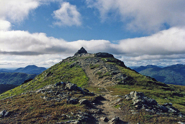
NN2626 : The summit of Ben Lui
Russel Wills
Hill facts and local notes
Classifications
Elevation
1,131m
3,712 ft
Prominence
876m
Coordinates
56.3970, -4.8105
NN266262
OS Map
50
Explorer: OL39N 364N 377E
At the Summit
The main summit is the southeast cairn at NN 26639 26288, 1,131.4 m above sea level. Ben Lui NW Top, about 150 m northwest, is lower at 1,127 m. A short dip separates the two. The summit edge overlooks the steep Coire Gaothach.
Terrain & Geology
Ben Lui lies in the Dalradian metamorphic rocks of the southern Highlands. The British Geological Survey describes the Ben Lui Schist Formation as mainly schistose to gneissose semipelite, with local psammite. NatureScot records calcareous schists and limestone outcrops within the wider SSSI, helping support its unusually rich upland flora.
Views & Scenery
In clear weather the summit looks across the southern Highlands, including Ben Oss, Beinn Dubhchraig and the mountains around Loch Lomond. Wider views extend towards the Crianlarich hills, Rannoch Moor and Glencoe. The Glen Cononish approach reveals the twin summits and the bowl of Coire Gaothach.
History & Heritage
Name Origin
Beinn Laoigh is the Gaelic name; the Gazetteer for Scotland translates it as 'hill of the calf'.
Historical Significance
Central Gully was first climbed in 1891 and is a historic Scottish winter mountaineering route. It is a Grade I winter climb with avalanche and cornice hazards, not an ordinary hillwalking route.
Getting There & Facilities
Parking
Dalrigh car park (NN343291), off the A82 south of Tyndrum, serves Glen Cononish. The western start is the Forestry and Land Scotland Glen Lochy car park (NN239278), on the south side of the A85 between Tyndrum and Dalmally. On 17 October 2026 FLS listed £3 all day or £1 for up to one hour, payable by card or RingGo, with free parking for clearly displayed Blue Badges. Its nearest postcode, FK20 8SB, is at Arrivain 2¾ miles east, so use the actual car-park location. Keep entrances and access tracks clear.
Public Transport
Tyndrum has rail and bus connections; Tyndrum Lower station is managed by ScotRail. Reaching Dalrigh from Tyndrum adds about 2.5 km of walking along the West Highland Way, outside the Dalrigh route itself. Check current services and allow for the full mountain day before choosing a return connection.
Nearby Facilities
Glen Lochy has a riverside picnic area. Forestry and Land Scotland identifies Dalmally and Tyndrum as the nearest places for toilets and food. Carry food and drinking water for the mountain; the summit has no facilities.
Safety Information
Known Hazards
- The Glen Lochy approach requires an unbridged River Lochy crossing. In spate the river and the Eas Dàimh railway underpass are impassable. Water levels can change before the return; turn back if a crossing cannot be made safely.
- At Glen Lochy use only the low Eas Dàimh walkway beneath the railway. Do not climb railway fences, walk on the tracks or use a railway bridge as an alternative crossing.
- The Dalrigh route avoids the River Lochy ford but crosses the Allt an Rund near the head of the Cononish track. This burn can be difficult after heavy rain.
- Steep rocky paths, wet grass, loose stones and boggy forest ground require care. Crags fall into Coire Gaothach; keep to the planned ridge route and confirm the correct descent in poor visibility.
- The northwest cairn is lower than the main southeast summit. Do not descend directly into Central Gully: it is a technical winter-climbing route, not an ordinary walking approach or descent.
- Forestry operations can alter the Glen Lochy approach. Follow signed diversions and keep clear of working machinery. Take care at the fast A85 car-park entrance.
Seasonal Hazards
Coire Gaothach can retain snow into early summer. Snow and ice turn its approaches and ridges into serious winter terrain, with avalanche danger and cornices above the corrie. Winter travel requires suitable boots, ice axe and crampons, the skills to use them, and winter navigation and avalanche judgement. Central Gully requires winter-climbing competence and is excluded from the walking routes. NatureScot's stalking table, updated 23 September 2026, lists no stalking issues northwest of the Beinn a' Chleibh–Ben Lui ridge; south and east of the group, Glenfalloch Estate lists stalking from late August to 20 October (07966768477). Follow the relevant local access advice.
General Safety Tips
- Check weather conditions before setting out
- Carry appropriate clothing and equipment
- Let someone know your planned route
- Take a map, compass, and GPS device
- Carry emergency supplies: food, water, first aid kit, torch
Hills
Some common questions about the hills answered
Are there group walks up Ben Lui [Beinn Laoigh]?
Many walkers use Walkmates to join or organise walks with others. You can check for group walks around Ben Lui [Beinn Laoigh] through the maps
Are there other walkers around Ben Lui [Beinn Laoigh]?
Activity varies by location and time, but Walkmates lets you see whether others have shared walks or shown interest in this area. Find other people through the walking friends search walking friends for Ben Lui [Beinn Laoigh] search or of course create your own walk for Ben Lui [Beinn Laoigh]
Can I organise a walk to Ben Lui [Beinn Laoigh]?
Yes. If there aren’t any walks listed already, you can create a walk and make it available for others to join.
If you're signed up to Walkmates, you can create a walk to Ben Lui [Beinn Laoigh].
How do I find a walk up this hill?
There are often multiple ways to walk this hill, depending on experience and route preference. Walkmates helps you explore walks and routes that others have shared.
Can I suggest a new route up Ben Lui [Beinn Laoigh]?
Yes. You can suggest or create routes to share with others. Walkmates focuses on the social side of walking, so routes are used to help people organise walks and explore areas together, rather than as detailed navigation tools or route libraries.
Other uses really appreciate knowledgeable walkers sharing their routes. Share your favourite route to Ben Lui [Beinn Laoigh] here
The is an error or something incorrect about this hill. How do I let you know?
We always strive to keep the information on Walkmates as accurate as possible. If you find an error, please let us know through the contact form and we'll aim to correct it as quickly as possible
Community Discussion
Comments
Location
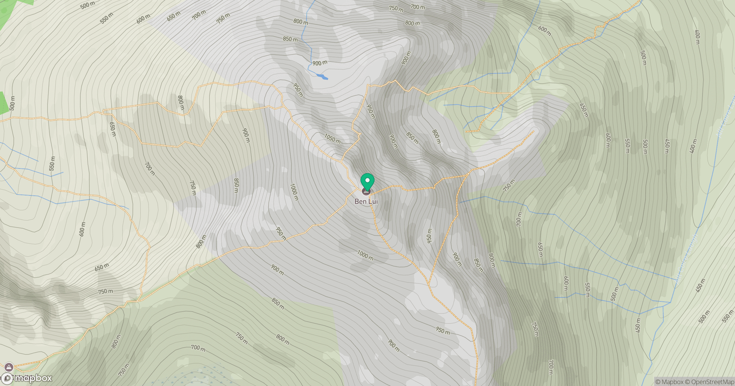
Grid reference: NN266262
View on OpenStreetMapOpens a map in a new tab, centred on the hill.
No comments yet. Be the first.